How to anticipate the risks of flooding? Thanks to the "Blue Managers"
NEWS

As the world's foremost natural risk, floods threaten 3.5 million homes, 18.5 million people, and 14.3 million assets in France. With climate change, costs are skyrocketing, but adaptation solutions are emerging. Leading the charge are the Blue Managers. Because it's not just a technical issue, but also a human and managerial one.
In the spring of 2025, historic floods ravage the Dordogne. Extreme rains, impermeable soils, rampant urbanization… floods hit more often, more intensely, in areas once deemed safe.
Yet, models based on historical floods are no longer sufficient to anticipate a climate in full transition. Risk assessments are evolving. Digital twins and climate projections now allow for evaluating water levels and probabilities of occurrence at the scale of a specific address, and for identifying adaptation solutions.
Powerful tools to be shared with Blue Managers to accelerate the resilience of territories.
Recently emerged in the wake of educational initiatives related to the climate transition, Blue Managers embody a new generation of professionals trained in sustainable water resource management and the anticipation of water risks. This movement is increasingly resonating in academic work dedicated to Blue Management.
Reference Flood
In France, flood-prone areas are delineated by municipal flood risk prevention plans (PPRI). Based on historical logic, they extrapolate water levels from observed or modeled floods, relying on flood markers to maintain the memory of danger.
An area is flood-prone if it is exposed to a reference flood. In France, the centennial flood is generally referenced. Its level is estimated from historical observations, series of maximum flows, and hydrological calculations. The PPRI then divides the territory into three zones: red, prohibition to build; blue, possible construction with adaptations like raising; and white, without specific rules but not without risk.
Floods in Île-de-France: 88% of natural disaster decrees in forty years
The current approach to risks presents serious limitations: it ignores the impact of climate change. While the IPCC forecasts a stable annual water volume in France, its distribution is changing rapidly: longer dry periods, shorter rainy seasons, less frequent but more intense rains. It also overlooks the cumulative effects of urbanization on water flow and neglects flash floods caused by rainfall runoff. In Île-de-France, these events accounted for 88% of natural disaster decrees for flooding between 1982 and 2021, affecting 1,090 municipalities. Nationally, approximately 175,000 residents are directly affected each year.
The current method smooths climate variability and underrepresents so-called millennial floods, which have a return period estimated at one thousand years, or a 0.1% annual probability. The PPRI sometimes mention them informatively or for sensitive infrastructures without imposing constraints. It remains possible to build where only the centennial flood is considered, whereas the natural disaster base (Cat-Nat) shows that millennial floods are already occurring at frequencies close to decadal or triennial floods.
Digital Twins
The flood occurs in three ways: fluvial, through the overflow of a watercourse or the rise of groundwater; coastal, through marine submersion; or pluvial, through runoff. To enable territories and enterprises to adapt better, it is essential to measure risk precisely: expected water height, flow speed, and the most likely occurrence period. New geolocalized evaluation solutions now meet these needs and feed digital twins like that of the city of Angers.
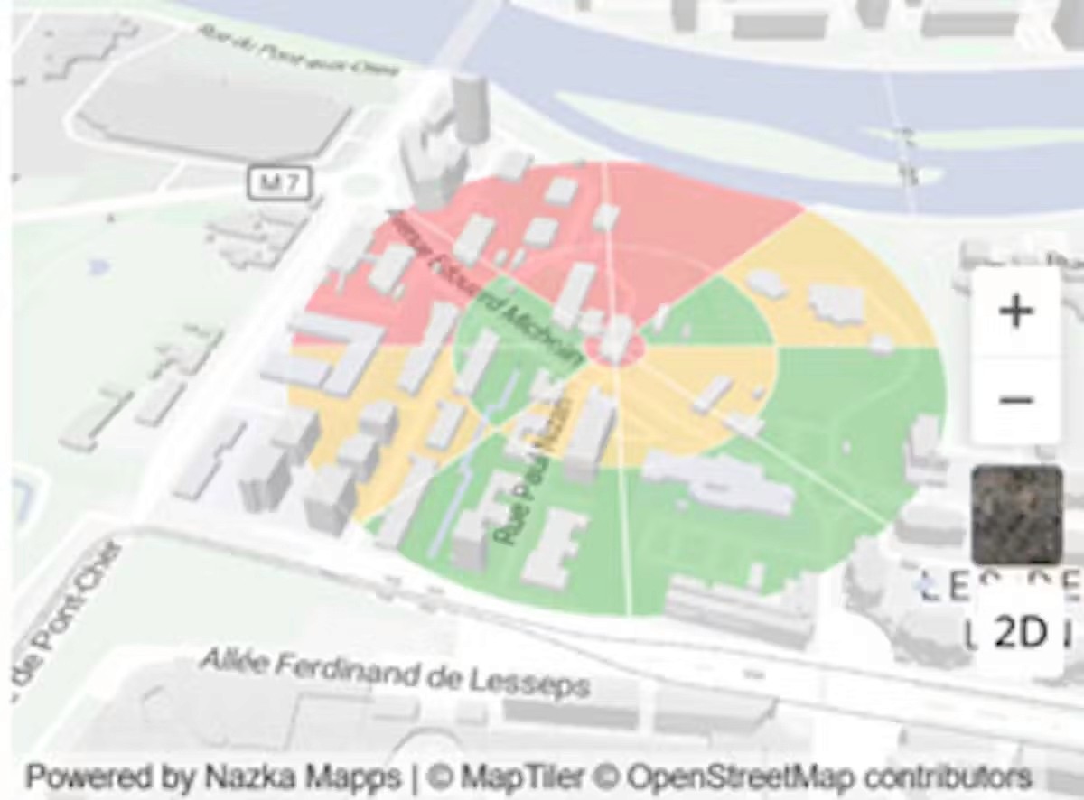
Figure 1. Simulation of a flood of the Cher River in Tours with a digital twin. The circles mark radii of 20, 100, and 200 meters; the colors indicate simulated water heights. Source: Tardigrade-ai.com.
A digital twin of a site is a detailed virtual replica of a real location. It aggregates, at a fine scale, data about soil types, building heights, forest cover, slope, and urbanization. These data primarily come from satellite imagery, Lidar surveys, and high-resolution digital elevation models such as Fabdem or Copernicus GLO-30. A digital twin also incorporates evacuation infrastructure (pipe diameters, networks) as well as upstream defense mechanisms on watersheds (dikes, retention basins, dams).
To this digital twin, we apply current and future precipitation regimes. Thus, climate projections are integrated into hydrological models and applied to the digital twin of the site. These models allow for estimating the resulting water height from flooding at any point on the globe, at the GPS coordinate and surrounding area, along with the associated seasonal probabilities of occurrence.
Nearly €24.8 billion between 1982 and 2022
Using damage functions from reinsurance, these probabilistic water heights are then instantly converted into financial damages based on the nature and use of each building. A geolocalized weather alert system complements the tool, with thresholds triggered adapted to the diagnosis. Why? To ensure the operational resilience of tomorrow and the asset resilience of the day after tomorrow.
As the world's foremost natural risk, floods threaten 3.5 million homes, 18.5 million people, and 14.3 million assets in France. Between 1982 and 2022, €24.8 billion has been paid out under the natural disaster guarantee, half of which was for flooding from runoff. These sudden floods, exacerbated by urbanization and changing precipitation patterns, quickly overwhelm drainage systems.
According to the Caisse centrale de réassurance (CCR), the cost of flooding will only increase in the coming years.
Decision-Making Tools
Risk managers now have real decision-making tools. They have more actionable and reliable objective criteria than the color zoning derived from the PPRI. Water heights, 3D visualization, and financial damages allow for pre-filtering adaptation solutions, such as removable barriers to relocation, or establishing safety plans for assets and people or business continuity plans.
Digital twin with flooding probabilities in Nantes (Loire-Atlantique). Source: Tardigrade-ai.com.
Blue Manager
But adapting a site or building to floods is not just a technical question. Translating information into an actionable plan that is adjustable over time and impacts the conduct of activities in case of a major event is not so simple. The perception of risk differs from one actor to another facing the same information, even when faced with alarming data.
Resilience emerges as a governance challenge, a perception of risk, and also pedagogy. These roles especially fall to Blue Managers to globally steer the paths of adaptation.
A Blue Manager is a conductor responsible for holistically managing the strategic management of water and associated risks. He occupies a transversal position between urban planning, climate, engineering, and crisis management. He engages in planning and governance, with the ability to interpret and contextualize the information and tools at his disposal to coordinate continuity and action plans.
Innovative approaches are developing to train them. The idea: to make risk tangible and adaptation operational. Training Blue Managers and equipping them with the means to act using new diagnostic tools is undoubtedly the greatest prevention against future floods. Floods – and climate more broadly – are a matter of management!